Monday, 19 October 2015

It doesn't always go your way: A super-typhoon during our visit to Taiwan


I remember looking at the weather section in the Taiwan guide book and clearly reading the warnings of typhoons during the summer months. A "grade ten" typhoon passed through Hong Kong while I was there and the worst I witnessed of the damage were fallen trees. It literally blew overnight and gave us clear skies the next day. "It wasn't so bad last time, how bad can it be next time?" I thought. This is the moment I looked back to as we walked through the damages of the typhoon: bent street signs, loose debris on the loose... being almost flown away by the wind. I would choose this time to back to and kick myself if I could. However, I knew I was in for trouble a while before the typhoon hit Taiwan, when we landed and loaded Facebook as soon as we connected to the hostel wifi: "Supertyphoon heading towards Taiwan in the next few days" was the first shared link I see. Shit.

Being in denial in Taichung   


My first move was not the smartest move. I thought, if I don't know when the typhoon is about to hit then I can keep being optimistic that it would never hit Taiwan while we're here. Sounds perfectly logical and scientific, right? So we put our heads down to stay naive and kept to our plan which was heading down to Taichung as our first destination. The city is located on the west coast of Taiwan and only half an hour away from Taoyuan Highspeed Railway Station. Our first sight of the trip was Lukang, a small town with beautiful temples and photogenic winding narrow streets. We started at Longshan Temple and then we followed the Lonely Planet street tour which guided us to some historically relevant sights between the temples (though not all as equally exciting... such as the Half-Well, ahem). We came back to Taichung in the late afternoon and took a break at Chun Shui Tang Teahouse, which is supposedly the birth place of Pearl Milk Tea.


Our last stop of the night was Fengjia Night Market - one of the biggest night markets in Taiwan. We thought that Taichung was very quiet city for one that is one of Taiwan's biggest but as we rode the bus into the night market, we realised we were clearly staying in the wrong part of town. You're not even near the entrance when you notice the mass crowd heading in one direction. Bright lights and smoke filled in the air and suddenly we were unloaded onto an endless chains of stalls and shops. I love night markets, so don't get me wrong when I say I was a little frustrated at the simultaneous overload and restriction of what my choices were. East Asia is not so easy when you have diet restrictions (they love their pork in East Asia) and top that language barrier, it can be really hard to get around food markets and to satisfy your hunger. 

Eye to Eye with the Typhoon in Taipei


The day we went up to Taipei was a relatively stressful one. We tried to find the Laughter Tea House and visit the Confucius Temple but both were closed. Having already wasted most of the day, we sulkily moved onto Taipei. As we were being shown to our rooms in Taipei, the staff joked how we arrived just in time for the typhoon and it was heading this weekend. As if the day couldn't get any worse. I couldn't be in denial anymore and so James and I put our heads together to make an itinerary around the the potential timing of the typhoon - what we wanted to see the most vs what sights are near each other. 


On our first day, I jumped out of bed to see sunshine and clear skies - we needed to make the most of this beautiful weather stat! We started the day with the Elephant Trail to get the breath taking view of the Taipei 101 tower among the rest if Taipei 101.  We then took a train to Longshan Temple, a beautifully intricate temple squeezed between regular residential and office blocks of Taipei. My second favourite place in Taipei was next on the list and it was the Chai Kai-Shek Memorial Hall, where the National Theatre and National Concert Hall can also be seen. We saw the Changing of the Guards and walked around the Gardens. In the evening, we went back to the Elephant Trail to catch a sunset view of the the Taipei 101. In the morning, the platforms were empty and all for us to make the most of but everyone is just waiting for the evening to get the money shot. The rain started coming in and it was the first sign of the approaching typhoon. I stayed until it hit pitch black but it wasn't without a little sacrifice of getting soaking wet. 


The rain were getting heavier and the wind was getting stronger, but we didn't let that tame our wanderlust. On our second day, we set out for the National Palace Museum which showcases some of the few treasures of China that were sent to Taiwan to protect from the Cultural Revolution. No trip to the National Palace Museum can be complete without a visit to the amazing Jade Pak Choi. While James and I love to indulge in a foreign country's culture, art has never been our forte (we prefer food culture) and could only spend a few hours before the visit felt like a drag. It didn't help witnessing new tourist buses overloading a new group every second and being swarmed by the growing crowds and tour groups. We made a visit to the Confucius Temple and Baoan Temple, which we had all to ourselves, before the rain became unbearable. In the evening, we explored more of Ximending, one of my favourite places of Taipei. I'm a shameless shopping addict and I loved the way Ximending came luminous and alive at night. This is where all the clothing stores, korean skin care and accessories can be found as well as some quirky food stalls. We ate some beef that had been BBQ'd with a blow torch, tried some baked potatoes with cheese and pineapple and enjoyed hotpot with duck liver. Ximending is the place to stay if you want to be at the centre of all the action. 


The eye of the typhoon swept over Taipei overnight. Every now and then I would wake up in the middle of the night to hear the heavy rain and the wind banging against the buildings. Unsurprising, weather for the third and fourth day weren't so great as the rest of the hurricane passed Taiwan. We thought we'd have a look at the damage and walked around Dihua streets in the morning where we were warned by a passing Police Officer to take care and we witnessed large pieces of debris being swirled and lifted once or twice. We went to see the Sat Yuan Sun Memorial, closed due to the typhoon, and decided to take pity on ourselves (on the current situation) by ending the day at Beer and Cheese Social House. The fourth day was less of a success: we planned to visit the Beitou Hot Springs but all the outdoor springs were closed due to cleaning up form the typhoon damages (you mean they didn't do it overnight?). Luckily the indoor hot springs where still on offer but they don't offer the same experience. We went back down to Shilin where a friend and her husband showed us about Shilin Night Market and we caught up on their life in Taiwan. He made us try Stinky Tofu, Buns and Shaved Ice. Shilin Night Market felt endless, every corner filled with new kinds of stalls ranging from clothes to food to toys... I could have seen myself getting submerged and lost at the next turn. 

Post Typhoon Recovery in North Taiwan


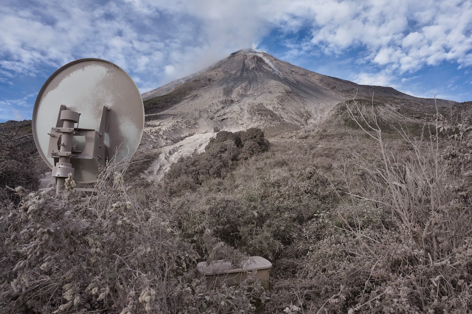
It soon became clear that we couldn't be optimistic about continuing our itinerary onto Hualien. Despite that being the main drive for our trip, we couldn't fight the struggles of the typhoon any longer as the National Park website declared all trails closed. Luckily North Taiwan still had a lot to offer in terms of beauty and culture, so we grabbed a train to Jiufen on our penultimate full day. For those who love Ghibli Studio movies would know that this place is one of Miyazaki's inspiration. Beautifully decorated with lanterns, the place looks pretty at day but even more spectacular night. We spent most of our time at the Jiufen Tea House and then walking around the streets and picking our a tea set to pass the time until night. We didn't have any plans to stay for or after sunset but I had a hunch that we should. We noticed the tourists gathering on the streets and we joined in to see the beautiful lit buildings. Unfortunately, Jiufen is very tightly squeezed together, the narrow side streets may be fun to explore during the day but it becomes suffocating and difficult to bear with the extremely busy crowd. The streets were filled wall to wall with people and the police had to come in and control the crowd. Our memories of Jiufen still reflect the tea houses and lanterns, which I look back at warmly. 


Our last night we went out on a bang. A trip to Taiwan would not be complete with a visit up to the Taipei 101 (thought the view of Taipei 101 is much better than the view from 101).  The love of mascots if definitely clear as you learn about O Bear and the Damper Babies. We then headed up to Shifen Railway Station. The railway station is on the Pingxi Branch Line, a former coal mine railway that is mow a photography paradise for the Taiwanese Youths but more famously, the site of theAnnual Lantern Festival. Visitors can come in during any time of the year to decorate their own sky lantern which they can realise into the sky... we couldn't resist!  


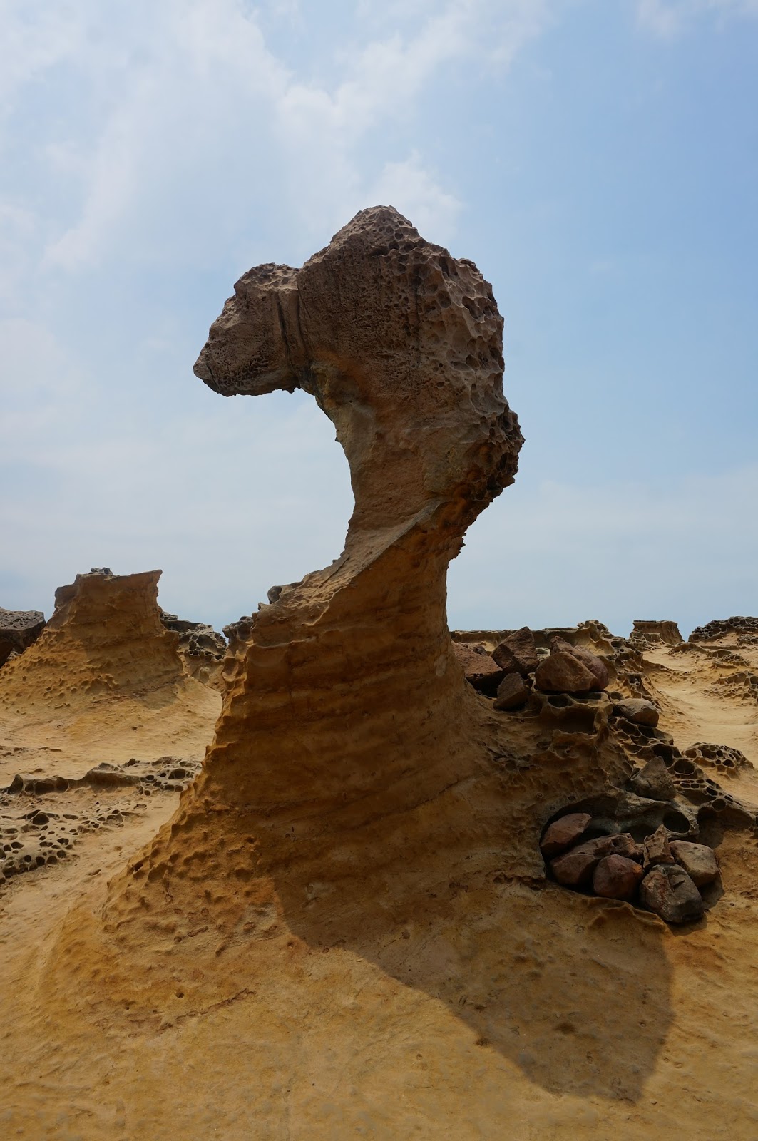
We still had half a day left before we caught our flight to Yogyakarta. Hualien was still off limits (sadly) so there was only one plan we hadn't visited it: Yehliu National Geopark. Now, the word "Geopark" may give you the impression of spectacular geological formations and dramatic landscapes when in reality Taiwanese love this park because if you squint hard enough, the rocks look like things. There are rocks that look like candles, birds, ginger. The highlight of the park is the rock that looks like a "Queen's head"... maybe if you look at it from a specific angle. Visitors have fun running from one rock to another, trying to find out what it's suppose to look like while the park staff spend their whole day blowing this whistle telling pesky tourists they are crossing the line.

Lessons Learnt from the Experience


This isn't the first time I've told myself not to go to East Asia during the summer - Last year in China we experienced miserable rains during the time we stayed in Hangzhou and in Thailand, we had flee from the monsoon once per day. Now that I don't have fixed holidays, I have more freedom to choose when to travel (if I am on top of my work). Looking at the climate will be my second top priority when choosing somewhere to travel and I'll focus looking at travelling during shoulder seasons when I can. What to do if I have no choice but to travel during low season? I need to learn to be flexible - or be willing to spend more money and research how the typhoon affects different parts of the country. Looking back on my Taiwan trip, I should have made a typhoon friendly plan. I know the west coast is less affected by typhoons and speaking retrospectively, I would have done Hualien first and then Taichung last. More importantly, I need to check the weather!


It wasn't all gloom and doom for my trip to Taiwan. I do feel a little selfish complaining about a typhoon during a trip when this is a regular occurrence in numerous countries which always end with devastations. But no typhoon can keep Taiwan's spirits down and even when the hurricane was still moving over Taiwan, the people were already at work to restore Taiwan to normalcy. Taiwan is one of those countries what treat their tourists like guests. Despite the language barrier, people were prepared to go out of their way to help us. If we looked like we were struggling to find which bus to go on, they'll stay by us and point out which one to take, when we tried to take photographs of the sunset, a photographer gave up her spot for me and when we tried to order food they'd respond with such enthusiasm that I felt like I was in a surreal child's TV show. Taiwan was a incredibly beautiful country for its culture, atmosphere and especially for its people.  

Wednesday, 1 July 2015

Leaving our hearts in León

When one adventure ends, another begins. After spending three months in Mexico, my plan wasn't to go home straight away, no way! Mexico is only a few steps away from Central America, a region I've associated with volcanoes, national parks and natural beauty, so I knew that once my internship ended I'll be heading there. My excitement to explore C.A. started even before I left for Mexico. I spent my last day in Mexico in Guadalajara before hopping on a plan straight to Panama to make my way to Nicaragua, my introduction to Central America.

Our first stop: León! 

León is the second biggest city after the capital Managua: A university town that is rich in culture and history ... and near the Maribos volcanic chain, so it's not surprising that are first on our itinerary. León was originally the capital of Nicaragua and still shows signs of historical revolutions and civil wars in forms of bullet marks and museums.

We spent our first evening in the town square. We sat on the steps of cathedral and watched the town of León. Children on bikes, couples on benches... Leon was probably the most foreign place I've been to (I knew very little about Nicaragua's history and current affairs compared to other countries I visited) but the scene in front of my was so homely. On my first full day in Nicaragua, we spent walking around the city centre with the Lonely Planet Walking Tour as our guide. There's an abundance of churches and small museums in León, which was perfect for taking a break in the shade from the intense dry heat. 

Volcano boarding in Cerro Negro 

...Was the highlight of trip, hands down. When we discovered that volcano boarding in León exists, we knew we were going to do it. Before we ascended the volcano, we were given a talk about how much we will be hiking, how to hold the boards (Fehn and I scoffed at when she warned us that she's seen small girls being flown off at the top) and what to do if there's an eruption (I doubted their management when she couldn't answer someone's question on how to tell an eruption will happen), but I never anticipated how difficult the I would find the whole experience. Now I only speak for myself because, as I have said many times, I am dangerously unfit. I could feel myself becoming incredibly weak by the time we reached the halfway point. When we finally reached flat land, I expected the hike to become easier... but I never accounted for what felt like a windstorm. The volcano was not that high, I've climbed higher! How can the wind be this strong? I could feel the wind pushing hard and I genuinely feared that I would be flying off the side of the volcano (the irony!). I had to walk down lower into the volcano so that I was being pushed onto it's side rather than taking the risk of being flung off the ridge! 


We were asked if we wanted to have a second turn but just thinking back to the whole trek to the top had me me in doubts but Fehn convinced me we can do it (this is why I liked travelling with her, the adventurous optimist). We did it once, we can do it again! That adrenaline quickly went away as soon as we approached the slopes and I descended into exhaustion and regret. It's moment like this that you really appreciate the kindness of strangers. One of the other VBers offered to carry my board (he carried two!!) and waited for me as I ambled up Cerro Negro. My second slide down the slopes of Cerro Negro wasn't as smooth and I ended up tumbling down the volcano at the end of the slope. 

But I would do it all over again if I had the chance to. 

We climbed the roof of Central America's largest Cathedral 

... And saw the hollywood image of heaven: pure white. We took off our shoes and my feet immediately began to tickle as soon as I stepped on the pristine root top. I had to wear my sunglasses because I was literally being blinded by the whiteness: my perception of depth was gone and I couldn't see if I was walking on something flat or curved. You could see all of Leon from the top. The Cordillera Los Maribos volcanic chain could be seen in the northeast. Telica stood out bright red from the rest of the chain and Momotombo looked perfect, despite it's infamous history of forcing the town of León to relocate after 1610 eruption. 

Eating the best (& the worst) Nicaragua had to offer. 

Maybe it's a little sad to admit that the best food you had in Nicaragua was the first dish you tried. When we arrived in our hostel, the directed us to a BBQ stall behind the Cathedral. Central America is infamous for it's boring cuisine that is mainly centred around rice and beans with a side, but it was good. There's normally two BBQ stands, almost identical to each other but equally as successful (we tried both). There's a big bowl of gallo pinto and a huge selection of BBQ'd meat and vegetable for you to pick and choose. We thought we should be good and try a new eatery every night but nothing was able to compete with the meal from our first night. It wasn't just dinner that we enjoyed in Nicaragua. There was a juice bar called Jugoso in the town square, opposite the Cathedral, where we spent all sunsets trying different combinations of fruits. On my way back from volcano boarding, I had sour mangoes covered in chilli and salt (one of my favourite snacks). On our last day we tried Raspados, shaved ice with syrup on top. 

Now for the worst... we all know that when there's a language barrier, you're bound to fall into some mishaps. Neither Fehn or I knew any Spanish. So you can imagine that we fell into several mishaps. I tried to learn some while I was in Mexico but my co-volunteers were so considerate in looking after the group that I learnt very few phrases. I could order food and if the server replied "Si" then things would be all fine and dandy. What I was unprepared for was anything else they might reply. This happened when I tried to order our first breakfast (pancakes and fruit salad) in Nicaragua. Now not understanding what see was saying, she pointed repetitively at the lacking buffet which I understood was our only option in the cafe. The buffet had three items: a questionable looking fish (Fehn did not eat chips), tortilla chips (I don't like tortilla chips) and these square yellow blocks that I thought looked french toast. I opted the latter for both of us. Imagine the surprise on our face when we expected a sickening sweet and greasy toast to be sickening dry yet greasy pure cheese. Imagine the further surprise we had when the lady behind us was served fruit salad a couple of minutes later. 


Soul Warming León 

We wanted to León to be our last stop as of a saying we kept coming across: "You will fall in love with Granada, but leave your heart in León". This proved a little difficult when planning our itinerary around Mombacho, which has specific opening days. I was debating if I preferred León or Granada. While the latter had more to offer its visitors, I liked how León felt more cosy and calm. León definitely has a more backpacker-y feel to it: the town is sprinkled with hostels and I hardly saw families and older couples. I loved the hostel we stayed in, Hostel Ivana, even though we stayed in a dorm. The staff were incredibly friendly and helpful, and I met some incredibly insightful travellers. In León itself, the views were picturesque and sitting down in on the steps of León Cathedral in the evenings watching the locals unwind and enjoying time with their friends and family was one of my favourite moments in León.    

Thursday, 22 January 2015

Photoessay: Flying to Volcán de Colima


Flying to a volcano, flying around one of Mexico's most active volcano,  has been the highlight of my time in Colima. I know I haven't finished my volunteering trip but this combines my childhood love of flying with my obsession with volcanoes. I've been looking forward to this opportunity the minute I was told about it (and I had to postpone twice because of other visitors) but it was worth every single penny and seconds I had to wait. Volcán de Colima is absolutely beautiful, from the ground to the sky. 

Getting ready for LIFT OFF

Nick arranges these flights to happen once a month as a way of monitoring the volcano. He needs two volunteers: one to handle the thermal camera and another to take digital photographs. Other volunteers can go on the flight as "tourists" if they are lucky and enjoy the whole ride while the main two have to panic about making sure the equipment doesn't start misbehaving and taking the images of anything that is relevant. 

We waited eagerly for an email from Nick at 7 AM to check if the flight was happening. If there is a single low cloud, the flight is called off. You need the perfect weather conditions. Around 7:05 AM we got an email simply stating "Great conditions! See you at 7:30" and the rest of the day literally flew by.  

The truck was being repaired at the mechanics (again) so we had to take a taxi to the airport.
Check out our six-seater sweet ride. Possibly the smallest plane I've been on. 

The best part of being in charge of the thermal images is that you get to seat on the co-pilot seat!
All the passengers before lift off!

Coming face to face with the volcano

The whole flight is about an hour but the actual flight around the volcano is about fifteen minutes. You can't help but stare out the window for the whole trip, the landscape around the volcano is beautiful too. The land is so green, splattered with a few small towns and farms, and the sky was blue... it was the most scenic combination. I had a permanent grin on face the whole ride through.

An unknown little town as we were approaching the Colima Complex.
This is one of my favourite photos from the whole trip
An attempt to be artistic - the Comlima Complex with a view of the airplane's nose.  You can see the faint outline of the propeller.
My second favourite photo of the trip - where lush forest meets the hostile land. 
Cutting across the plume
Getting close to the summit. You can see the parasitic volcano twin, Volcancito, on the bottom left corner and the northern lava flow. 
The view of the whole Colima Complex from my window...
... And now the pilot's view 
Nevado de Colima and Volcaán de Colima side by side. Does it remind anyone of an old couple?
Although Volcaán de Colima looks taller in the photos, Nevado de Colima has a higher elevation of 4271 m compared to VdC's height of 3839 m. However, VdC is still active and growing, while NdC is being eroded away, so VdC may reign over the whole complex one day. The current activity of the volcano includes vulcanian eruptions and the growth of a lava dome (which began in 2007, I believe) that overspills to form the active lava flows around the volcano and rockfalls (which are beautifully incandescent!).

 Descending - Heading back home

Of course I was dreading the fly back home... "Couldn't we fly around the volcano for five more minutes" was what I really wanted to ask the pilot. A part of me wished I went on the plane as a "tourist" but I was pretty happy to sacrifice the time to take good digital photos just to sit at the front (I'm obsessed with taking photos of the volcano, I know). Despite me thinking the flight went smoothly, I accidentally left the GPS equipment on the plane (you can see where I left it on one of the photos) and the pilot didn't let us take the photos for Nick early enough, d'oh. I kept thinking on the way home that I would love to go for another flight, maybe I should go for it again. A month later, I think once was enough, I don't want to make the experience less special by going on it again (I think you'll only get the awe you feel for the first time once). Saying that... I can't help but glance back on the photos, it was an amazing trip.  

Aviation sunglasses, check. Gelled back hair, check. Collared shirt, check. I do believe we have a pilot here.
More evidence that I was in the co-pilot seat!
Approaching Colima airport
Couldn't help myself :')

Tuesday, 6 January 2015

Getting up and personal with a lava flow


Happy New Year, everyone! It's already a few days into 2015 (say what?) but I'm still in December mode. I remember how excited I was about NYE but now I'm in denial that 2014 is over. Now I should be moving on but there are some loose strings I want to tie up. I wanted to mention from my last moments of 2014, some exciting fieldwork that mades me realise why I want to do this peppered with a few moments that makes me feel like I'm not cut out for this work. One such field trip was to El Playon, potentially the best campsite in the national park because... it's the closest you can sleep to the volcano! How cool is that?

An action shot that Derek might appreciate
We made our way to El Playon just before eight in the morning. Even though the Volcano is named Volcán de Colima, it is still a good three to four hour drive. It was all the more important to leave early because from my previous post you will remember that I couldn't go to El Playon the last time we tried because of a certain landslide. We were prepared this time: this landslide was no trouble for 3 geologists armed with a shovel + 1 geologist armed with a pick-axe. Within thirty minutes we made ourselves a new road and strolled into our final destination.

Okay, I lie, the roads were cracked along the way and we had to stop again to fix up the roads. I accidently left two shovels behind but a shovel and pick axe was enough. I'm pretty sure we were doing the National Park's job! 

The truck can get a little crowded at times
I will admit the ride becomes exponentially bumpy as you leave the high way and into the national park. If you are sitting on the back of the truck, you will get hit by branches, showered by petals and leaves and have mud flung back at you. It's no luxury ride but the view... the view is incredible. The national park is hardly frequented by foreign tourists, though we met many from Guadalajarans, so it feels like this view is a little secret you have in Mexico.

Cosy for two
As soon as we arrived, we set up camp. Before Mexico, the only other time I camped was for a practise Duke of Edinburgh expedition, which was more of an old school type of tent. This one took approximately ten minutes to set up because of Delphine's expertise. I seem to be the only one who hasn't regular camped before because I was subsequently teased for taking a photo of my temporary home. We also set up the equipment straight away (or else we would be missing out on data!!) and I learnt how to set up the car battery and solar panel as a power source for the two types of camera. Unfortunately, learning how to set up an equipment doesn't mean you know how to dismantle it after... there might have been a small incident involving a car battery and crocodile clips melting, which has been so far the lowest moment of my fieldwork here. I've learnt, I've learnt.  

Sadly, an epic view was missed out on because of low clouds.
Around late afternoon, Nick and I set off to collect some "hot rocks" from the active southwest lava flow. It's a short hike from our camp but it didn't take long before I was finding it difficult to talk and walk at the same time. This isn't from the altitude, it's from how much my endurance sucks (potential New Years resolution alert). We've been on the volcano cone at least since the afternoon but you feel safe in the shelter of the lush vegetation, almost makes you forget you're on one of the most active volcanoes in North America. If you keep travelling further up, you'll be met by what can be described as barren land. Trees, flowers, grass cannot survive within the vicinity of the summit because the ashes can suffocate and burn any living creature. The transition from the beautiful scenery to a hostile environment lies around where earlier pyroclastic flows travelled to. The November pyroclastic deposits didn't travel as far as the ones that occurred earlier in the summer (August?) because there was still "fresh" ash a little way up.   


One amazing thing about view as you travel up to a lava flow is looking at the remnants of a rockfall. Every fieldtrip, we take turns recording the rockfall and from a far, these look like tiny specks if you can see anything at all (I use the dust cloud generated to spot them because my eye sight is very bad). From up close, you can see that these rockfalls that originate from close to the dome can be large as our truck! Some of them smash into smaller pieces on the way or on their final impact (like that photographed) while we did see a few that stayed better intact. Now if you didn't realise, but we were still vulnerable to these rock falls while we were hiking on the barren/active part of the volcano. Even wearing a helmet didn't make us invincible to the dangers of the volcano. Heck, what am I saying? There could have been an eruption any time we were up there, it's a fate I accepted. My best protection was to seek shelter behind a large rock.

You can recognise the darker, towering lava flow from the paler, rockfall remnants.
Now when I said lava flow, I'm sure some of you would have imagined a the gooey basaltic lava flows you see on Hawaii. Well, have a look at the photo above because that's what an andesitic lava flow front looks like. Much rockier and thicker than I expected to be if I'm honest. It's hard to tell from the photo but the lava flow is about 10-15 m high (in my opinion). I wish I could go up closer as a scale to show you how high the top of the flow is, but I didn't want to risk getting knocked out by a rockfall on the lava front (most of the rock falls originated close/on the summit but this lava flow front was generating its on rockfalls too). 

Nick found some "hot rocks" - rocks which were still warm hence fresh from the lava flow. He takes them back to be analysed at the university. We should have taken the thermal camera to see which rocks were the hottest but we forgot sadly! Luckily these rocks are warm enough to be compared by touch. OH and for the clarification, these were not on the lava flow itself but rock fall from the lava flow i.e. 10's meters from the lava flow. We wanted to come back alive. 


Nature knows how to fight back. I couldn't help but take a photo of this plant who obviously couldn't wait to start sprouting despite the rocky region. In the photo below, you see how hostile the volcano looks. Trees dying due to the pyroclastic flow deposits among new grass who are maybe a little too optimistic about their chances of a long life. 


Going up is much easier than going down. I fell down countless times because the ground was unstable (lots of loose rocks, big and small). We headed down soon after collecting some rock samples because it was sunset and we wanted to get back before it was dark. Unfortunately, the clouds started to lift only when we started descending the volcano at night looks as cool as volcano at night, if not more cooler.

Sadly, our trip to Playon wasn't as successful as we would have hoped. The volcano was pretty cloudy that weekend meaning we could only collect so much thermal and digital data. Luckily, Nick managed to get the flyspec working (another problem we had at Nevado) so we had that going for us. There were a few more trips, the others went to the parasitic cones, Volcancito, while we went to collect some 1913 rock samples and ash samples from the latest pyroclastic flow. A pretty full on trip, if I do say so myself, and boy were we glad to be home.


Tuesday, 9 December 2014

Ashes to Ashes: Post explosion field trip to Montegrande


With an explosion on Friday, there was excitement in the air. How big exactly was this explosion? Does the lava dome look different? How far did the pyroclastic flows travel? I was up til 2-3 am listening to other volunteers talk frantically about how they couldn't wait for a field trip to Playon to inspect the crime scene. Up til 3 am! Being around people while they talk about what they are passionate about is a good feeling, being around passionate volcanologists was a super good feeling.

The first field trip post explosion was a visit to Montegrande, one of the ravines on the volcano. Since there was four of us, I decided to join Bastian on the back of the truck, which came with a warning from one or two people and boy they did not exaggerate. I could feel my childhood motion sickness rising back up. Thank god the team got straight to work when we arrived (I didn't want to think about my stomach) and not a minute was wasted setting up the thermal camera.


We made a brief pit stop at an exposure on 2005 eruption deposit. Volcan de Colima was particularly active in that year, which included a large eruption in May that resulted in ash depositing at least 5km and volcanic bombs landing 3-4km. It even called for an evacuation of nearby towns, which goes to show that Volcan de Colima shouldn't be underestimated! Looking at the metres thick deposit, it's astounding how much the eruption left behind despite the its not one of the world's most threatening volcano (but it is one of the most volcanoes in the Americas).


Next on our list was to collect the infrasound data. We were crouching under the young trees discussing our excitement for Star Wars and Jurassic Park (yaaay!) trailer. And then it happened... a deep rumbling sound began. A large rockfall? No, there was a deepness to the rumbling... an unsually large rockfall? Don't be ridiculous... it was an explosion! An actually explosion! Nick yelled out what we were thinking and we all ran out from under the trees trying to get a quick glance before we missed it. Never have I simultaneously hated tall trees and being short because all I could see was just the top of the lava dome and the plume (but that's all I needed to see I guess). I think this trip is already overtaking the Nevado trip as first place (the bar wasn't that high to be fair).


We trekked through the vegetation towards the pyroclastic deposits from the Friday explosion. Here is where another disadvantage of being short comes in: when you are walking through thick vegetation, remember to wait a few seconds after the person in front walks through or else you are very likely to get smacked in the face with a branch. I was among tall people and no one understood my short people woes. However, the branches became the least of my troubles when we entered the realms of the ash. The world before us transformed: all colours vanished and replaced with this creamy brown. Every step a person took was vanished among a cloud of dust. It didn't take long before we were engulfed in it too.


We were also literally eating ash. That **** can get anywhere.


We clambered on over (or more like I did while the others strolled along casually) and from the the top of the ravine, we could see the transition between the ash and ash free. Pyroclastic flows stop abruptly. They loose momentum and just DROP DOWN EVERYTHING. You could see some of the plants bent slightly away from the volcano, which showed you that the flow wasn't that powerful, and the trees were unburnt, so it wasn't too hot. It was amazing to see how accurately you could draw out where the flow had stopped.


It was surreal walking in the field covered in pyroclastic flow. The plants were covered by only a mm thick (maybe even half a mm) of ash, but that was enough to wipe out any trace of colour. I could have stayed all day feeling like I was on a movie set but I wasn't keen on having ash filled food. We didn't manage to get everything done on the trip. Unfortunately the cable we needed to connect to the laptop at the radon station wasn't working (always check your equipment before you leave!) which only means another trip to Montegrande!